![]()
![]()
![]()
![]()
|
|
|
|
22nd September 2001 - 9.1 Miles & 3640ft Ascent
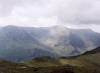
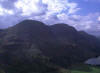
A rare solo weekend walk which found me in the village of Buttermere; arriving at approx 9.45am, my intended route for today would take me up to High Snockrigg, across Buttermere Moss and to the summit of Robinson. A traverse of Hindscarth edge to Hindscarth summit and then onto Dale Head. From its 10ft high cairn, I would drop down to the Honistor Pass below Grey Knotts and head across Honistor Crag for the summit of Fleetwith Pike, before descending to Gatesgarth and back to Buttermere. I had forgotten what a slog it was up-to Buttermere Moss, since the walk begins with an immediate steep climb out of Buttermere. The village quickly fell away behind me as Wandope and Crag Hill stood to the North (below left). The occasional cloud was captured by the tops as they rolled by, eventually rising above the tops as the day wore on. Buttermere Moss was drier than expected although still boggy in the middle. I didn't stop to take in the views of Buttermere from High Snockrigg as I had been here before, so I continued straight across the moss to climb to Robinson summit on the other side; keen to get some views from the tops before any low clouds came back to spoil them. After a brief stop to admire the views, I continued South-East along Hindscarth Edge heading for Hindscarth Summit. The High Stile ridge stood large and proud on the South-West side (below right) of the Buttermere valley as the Honistor Pass road and Buttermere lay in the valley below.
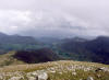
Halfway between Robinson and Dale Head, slightly off Hindscarth Edge to the East sits the summit of Hindscarth. A little beyond the summit a stone shelter can be found. Here, I enjoyed lunch and the views down High Snab Bank and across the Newlands Valley to High Spy, Maiden Moor & Cat Bells (below left). To the North beyond the Newlands Pass stood the South side of the Coledale Horseshoe round of Causey Pike, Scar Crags & Sail. After lunch, I made my way back to Hindscarth Edge and began the steady ascent up-to Dale Head, as the clouds once again began to gather and roll in over the tops. The views being totally lost by the time I reached the 10ft cairn on Dale Head summit, I turned South to pick up the track to Honistor Pass mine. As has often been the case in the past, 15 minutes after leaving Dale Head the clouds moved on leaving this routes highest point in the clear (typical <g>). Honistor Crag at least now came into view to the West (below right) as I tried to spot my intended route over it to Fleetwith Pike summit.
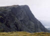
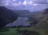
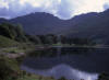
Dropping down to the Honistor Pass sitting below Grey Knotts, I turned North-West and followed the old mine track to pick up the route across the top of Honistor Crag (be careful - you could miss it). Reaching Fleetwith Pike summit I was quickly reminded why it isn't a good idea to hang around here, little black flies which had plagued my last visit here were once again in abundance. Due to its location, the views North-West from here stretch well beyond Buttermere, Crummock Water and Bassenthwaite Lake (below left) as Haystacks and the High Stile summits of High Crag, High Stile and Red Pike stand to the West (below right), and to the North-East the previously walked over Hindscarth Edge summits of Robinson, Hindscarth and Dale Head.
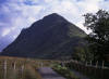
I began the leg burning descent from the summit to Gatesgarth passing the Fanny Mercer memorial, where I was greeted by the hordes of weekend "tourist" visitors to the area enjoying ice cream in the full Gatesgarth car park. Due to the foot & mouth restrictions still in place my return to Buttermere had to be via the road which, as it turned out allowed me to take some photos of Fleetwith Pike (below left) and Haystacks (below right) - Wainwrights favourite.
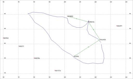
Arriving back at the Buttermere car park at 4pm, I reflected back on my days - both winter and summer - on the hills around Buttermere, having realised that I had bagged them all. Other hills reachable from here are easier bagged from closer locations such as Grisedale Pike. However, the varying difficulties of walking, scrambling and high level routes in this area will see me make many returns, as this has become one of my favourite locations in the Lake District. This walk was also the first time I had begun to use my Magellan GPS 315 properly, in conjunction with my recently purchased GPS Utility software. The data I was able to download has provided me with an ascent / descent profile and map route againt plotted waypoints map (data which can be overlayed on a scanned OS map, but for copyright reasons cannot be shown here).
Tracklog Route Against Plotted Waypoints - Data Extracted From GPS. |