![]()
![]()
![]()
|
|
|
|
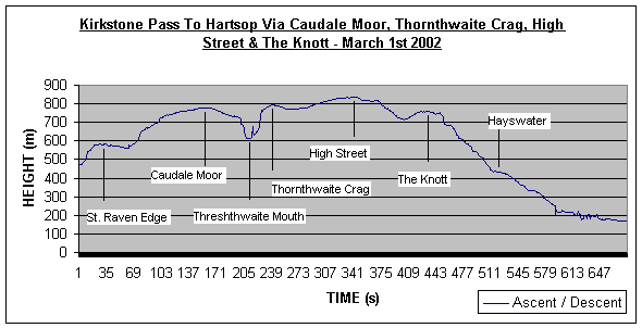
By extracting the altitude data from my Magellan 315 GPS and importing it into Microsoft Excel, I am able to produce ascent and descent profiles of my walked routes. In the profile below, you can see our starting point at the Kirkstone Pass and our finish at Hartsop, approx. 300m lower than our start. Our initial steep ascent onto the flat St. Raven Edge before a more gradual ascent to Caudale Moor and Stoney Cove Pike. After this point, the challenge of the day. A very steep descent to Threshthwaite Mouth with just as much a scramble ascent with more exposure, out and onto Thornthwaite Crag and its 15ft high "beacon". From here, a slight rise over a large distance to the routes highest point of 828m, High Street. A gradual descent from High Street before a short ascent to the summit of The Knott.
From the summit of The Knott, it's down hill all the way. The first part of the descent is to the outlet of Hayswater. Here the path meets with a more metalled track road which descends back to the village of Hartsop. |